Wildland Urban Interface Overlay

The purpose of the WUI-O is to reduce the risks to human life, property, livelihoods, and wildlife within areas with higher risk of wildfire, and to recognize and clarify the respective roles of the city and property owners in the WUI-O to reduce those risks.

Lands within the WUI-O are areas at higher risk for wildland fires and areas known to be frequented by wildlife. An increased risk to wildland fire will continue to be present in and around existing dwellings and new dwellings built in these areas, and it is the responsibility of the property owners within the WUI-O to assist the City to reduce those risks by maintaining their properties and avoiding actions that would increase those risks, as described in this Section 11-02-07.3.H.

See More About Sensitive Lands Overlay Districts

Depiction of Wildland Urban Influence Overlay District Boundary Map highlighting included area including the foothills and valley areas as well as the Boise City Limits.

Applicability, Exceptions and Compliance

Applicability

The provisions of this Section 11-02-07.3.H shall apply to the following activities, except as listed in Subsection (b) below:

i. All new structures and additions to structures constructed in the WUI-O after the Effective Date; and
ii. Renovation or modification of primary and accessory structures existing on the Effective Date that increase the gross floor area of the structure on the Effective Date by more than 49 percent.

Exceptions

The provisions of this Section 11-02-07.3.H shall not apply to:

i. Interior renovations, regardless of the gross floor area involved, unless they coincide with exterior modifications exceeding the 49 percent criteria given above.
ii. Renovation of historic buildings where the proposed renovation is necessary to replace or repair materials that have deteriorated, or to restore historic buildings to their historic appearance in accordance with generally accepted historic preservation practices.
iii. Relocation of historic buildings to recognized museums.
iv. Construction, renovation, or modification of accessory buildings used for agricultural purposes and located 50 feet or more from all buildings containing habitable spaces.

Compliance

(a) All properties and activities subject to this Section 11-02-07.3.H pursuant to Subsection (3) above shall comply with all applicable provisions of this Section
11- 02-07.3.H and with all applicable provisions of the Wildland Urban Interface Fire Code as set forth in Chapter 14 of the Boise City Code as adopted and periodically amended or updated.
(b) Should any provision within this Section conflict with any other provision of the Boise City Code, then the more restrictive shall control.

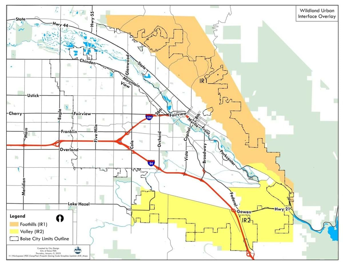
Wildland-Urban Interface Map and Classifications

(a) The boundaries of the WUI-O and the boundaries of the risk zones, IR1, IR2, and other subdistricts described below are shown on the zoning map of that base district, and generally follow natural and manmade features.
(b) These generalized risk zone boundaries are subject to interpretation by the Fire Code Official based on the most current fire site conditions and fire risk information, and that Official shall have final authority in determining which lots or parcels shall be included within the WUI-O district and the subdistricts described below.

General IR1 Areas

IR1 areas are required to use Class 1 Ignition-Resistant Construction (IR1), that generally include foothills fire hazard areas. As the City annexes land to the north and west, the IR1 areas will be automatically modified to include annexed lands that are generally north and west of Hill Road.

General IR2 Areas

IR2 areas are required to use Class 2 Ignition-Resistant Construction (IR2), that generally depict valley, desert, and other occluded fire hazard areas. Interior lots for IR2 areas may be allowed to use Class 3 Ignition-Resistant Construction (IR3) if the Fire Code Official determines that such construction shall not materially increase the risk of fire-related losses or life or property.

Other Fire Risk Areas

The Fire Code Official may identify additional areas at threat from wildfire, that may include but are not limited to properties adjacent to occluded undeveloped properties in areas not historically considered wildland-urban interface areas.

Other Applicable Code Considerations

  • Access Standards
  • Building and Structure Standards
  • Roofs
  • Building Appendages and Projections
  • Siding
  • Exterior Doors and Windows
  • Eaves and Soffits
  • Chimneys and Vents
  • Underfloor Areas
  • Defensible Space
  • Vegetation
  • Fencing
  • Incinerators, Outdoor Fireplaces, Permanent Barbecues and Grills
  • Storage of Firewood, Flammable and Combustible Materials
  • Keeping of Domestic Livestock

Message Sent Successfully!

Message Failed To Send.

Send a Message to Planning

Thank you for your interest in the Planning division. Please fill out the form below and a representative will be in touch with you. If you are inquiring about a specific project, please include the record number or project address.