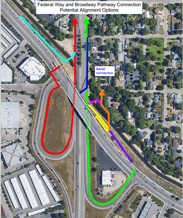
Broadway - Federal Way Pathway

Project Background

Project location: Near the Federal Way and Broadway Avenue interchange

Project background: This project began as a request for a bike and pedestrian connection between Federal Way and Broadway Avenue from the South Boise Village Neighborhood Association in 2018. A pre-concept report was developed in 2020 through COMPASS’s Project Development Program. The project was awarded federal funds in 2022 for design and construction.

Conceptual site map of Broadway-Federal Way Pathway

Impacts

This project will:

  • Provide new connections to several nearby schools, parks, commercial areas, and employment,
  • Close a 2.2-mile gap in the bike and pedestrian network,
  • Provide a continuous connection from the Federal Way Pathway to the Greenbelt,
  • Provide 1,600 new residents with access to a pathway within a 10-minute walk.
Broadway - Existing Conditions

Alternatives

The project team is currently reviewing and seeking public input on two alternative alignments:

Alternative 1: Eastern Loop Alignment

Alternative 1 would construct a multi-use pathway along the southern loop ramp and under the Federal Way overpass, connecting along the eastern side of Broadway Ave. A physical barrier would be placed between the pathway and roadway as it parallels Broadway Avenue. A new pedestrian crosswalk would be installed on Federal Way to provide access to the pathway.

Key Features:

  • Requires crossing Federal Way
  • Greater out of direction travel
  • Less-comfortable user experience under bridge
  • Lower project cost: $3,700,000
Alternative 1 - Perspective Rendering


Alternative 2: Canal Alignment

Alternative 2 places the pathway between the Ridenbaugh Canal and the Federal Way Bikeway. Using the existing canal slope eliminates all crossings of major roadways and provides a more comfortable user experience away from traffic. The steep slopes along the canal will require large retaining walls and additional fencing.

Key Features:

  • Continuous bike and pedestrian connection
  • No roadway crossings
  • More direct and intuitive route
  • More comfortable, further removed from traffic
  • Higher project cost: $5,800,000
Alternative 2 Perspective Rendering

Project Timeline

Please Note: Dates are tentative and subject to change.

  • Public outreach 1: October 2024 *we are here*
    • The public is encouraged to review the preliminary design plans and provide comments on their preferred alternative.
  • Select preferred alignment: November 2024
    • Public feedback will be carefully considered, and the final design option will be chosen based on community input and technical analysis.
  • Begin Final design: Winter 2024
    • The project team will finalize the plans, incorporating the selected alignment and any necessary adjustments.
  • Public outreach 2: Summer 2025
    • The public will have another opportunity to learn about the selected design, funding, impacts, and project benefits.
  • Complete Final Design: 2026
    • The project team will incorporate the findings of Public Outreach 2 into the design and prepare the project for bid and construction.
  • Anticipated construction: 2027
    • Construction is expected to begin, bringing the design to life.

Message Sent Successfully!

Message Failed To Send.

Send a Message to Planning

Thank you for your interest in the Planning division. Please fill out the form below and a representative will be in touch with you. If you are inquiring about a specific project, please include the record number or project address.